Monitoring Agricultural Practices
In 2017, LGROW was awarded a Regional Conservation Partnership Program (RCPP) grant through the Natural Resources Conservation Service (NRCS), part of the United States Department of Agriculture (USDA). A portion of the grant was allocated to fund conservation practices in two subwatersheds of the Lower Grand River - the Rogue River and Indian Mill Creek watersheds. These conservation practices include planting cover crops, creating grassed waterways, adding riparian buffers, and planting trees on agricultural lands and aim to decrease sediment runoff from agricultural practices that would otherwise end up in our rivers and streams. Sediment, typically from agricultural practices, is the dominant non-point source pollutant entering our waterways.
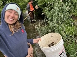
The RCPP grant requires monitoring of the funded conservation practices, and that the results are reported. To fulfill that requirement, LGROW staff recently sampled aquatic macroinvertebrates1 and surveyed habitat at seven sites – six in the Rogue River watershed and one in Indian Mill Creek – and surveyed habitat at three separate sites in the Rogue River watershed. Sites were selected to be above and below conservation practices and track habitat and “bug” scores along a continuum. For example, our first site was accessed from 18 Mile Road in Casnovia where we set up to sample Ball Creek, a designated drain and tributary of the Rogue River. We typically set our equipment on top of a culvert and begin with macroinvertebrate sampling.
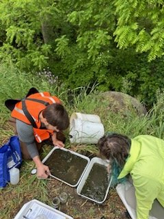
First, starting at the culvert and heading upstream, we measure a 300-foot section of stream. One person samples any available microhabitats within the stream (e.g. rocks, plants, muck, leaf packs), in proportion to their occurrence, with a D-net. Another person holds a bucket to receive whatever debris and organisms the net has collected. Together, both collector and bucket-holder work their way upstream collecting for the full 300 feet. Typically, every ten minutes or so, the bucket-holder will take the contents of the bucket back to hand off to another group of personnel – pickers – and get a clean bucket. This way, some of the sample can be sorted through while sampling continues.
Once picking is completed, organisms are usually euthanized in isopropanol or ethanol for later identification – this is done to save field time and increase accuracy and precision during the identification process. After completion of the macroinvertebrate sampling, a habitat assessment2 was also performed in order to complement the former. Often a habitat assessment will provide support for the results of the macroinvertebrate sample (e.g., an obvious source of pollution is observed and noted which explains a low macro score).
Over the course of the field day, we sampled six sites in Ball Creek, moving from upstream to down. This took three trained personnel about eight hours to complete. On a separate occasion, LGROW staff used print and virtual media to identify all specimens. The numbers of each kind (abundance) were counted, and then fit to a simple index. The result of the index is a water quality score and rating. Ratings run from Poor to Excellent. Returning to our first site, the rating ended up as Poor. This site in Casnovia is truly nothing more than a drain for agricultural lands. This means that the only taxa found are usually tolerant organisms which point to heavy pollution or impact. Our taxonomic inventory of this site – common to taxonomic inventories of any small, impacted stream – was dominated by small leeches, true bugs (air breathers) – mostly water striders – midge larvae, and one damsel fly family. This doesn’t mean that the conservation practice was a success or failure, but simply indicates the health of the “stream” at the time of monitoring. Even though a Poor rating was the result, the score improved significantly from sampling in the previous year. This, also, is not proof positive of the conservation practice’s effect, but simply another piece of data to be looked at and reviewed when analyzing the effect of the practice. We will use the data from this outing in conjunction with previous outings to help gauge the efficacy of the RCPP conservation practices. The results are reported as a mandate of the grant.
1. The method of macroinvertebrate sampling we use is the Michigan Clean Water Corps (MiCorps) volunteer monitoring procedure. This method is preferred because it has standardized scoring and is applicable throughout Michigan; scores/stream ratings are also posted on a website accessible by the public and professionals alike (see https://data.micorps.net/view/stream/).
2. Habitat assessments involve a series of questions that explore the health of instream and riparian substrate and document potential pathways of pollution/impact.