Fall MiCorps Sampling in the Rogue River
A Summary of the Fall Annual MiCorps Sampling in the Rogue River Watershed, 2023
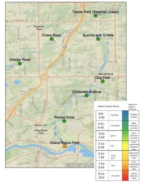
This past Fall, LGROW monitored water quality in the Rogue River Watershed using the MiCorps protocol. This monitoring was funded by a MiCorps implementation grant through MSU Extension (equipment, training, logistics, LGROW personnel); facilitated by the Rogue River Watershed Partners; and carried out with the help of our wonderful volunteer base! We had 30 volunteers and one LGROW staff member, Matt Bain (LGROW’s Aquatic Specialist), as the program lead. This allowed our volunteer base to divide into 6 teams and for each team to sample a single site. Two additional sites were sampled on different days for a total of 8 sites sampled in Fall 2023! All sampled sites, as pictured below, are in the Lower Rogue River Watershed (see Figure 1).
Figure 1. MiCorps monitoring sites in the Lower Rogue River Watershed
Our most upstream site was near Grange Avenue and our most downstream site was at Grand Rogue Park near the Rogue’s confluence with the Grand River. For those that are unfamiliar, the MiCorps protocol involves sampling a 300-foot stretch of stream or river for aquatic macroinvertebrates (water “bugs”) and completing a habitat survey of the in-stream and surrounding habitat (for more information, please see The Watershed News item “Monitoring Agricultural Practices,” posted July 25, 2023). The kinds and amounts of macroinvertebrates that we find are plugged into a simple index to generate a Water Quality Rating ranging from Excellent to Very Poor. The scores – as can be seen from Figure 1 – are counterintuitive as the lower the score, the better the water quality rating. Thus, 0.0-3.50 would be optimal and 8.51-10.0 would be extremely concerning.
Beginning upstream near Grange Road, our score was 3.74, the high-end of Very Good; the next site, traveling downstream, near Friske Road, scored 4.13, Very Good; Stegman Creek, our only sampled tributary, also scored Very Good at 4.22; continuing downstream, the site near Summit Avenue and 12 Mile scored 3.90, the high end of Very Good; a site near the Rockford Dog Park scored 4.06, Very Good; a site near Childsdale Avenue scored 4.29, Very Good; a site near Packer Drive, 3.82, the high end of Very Good; and our most downstream site, at Grand Rogue Park, scored a 7, for Poor. This last site scored Poor, automatically, because less than 60 organisms were collected. We are currently unsure what to make of this finding and plan to resample, with special attention, in the Spring; the initial finding was brought to a Michigan Department of Environment, Great Lakes, and Energy (EGLE) team member and the full data sheets will be shared with them as well.
Averaging the findings of all eight sites gives an average water quality rating of 4.40, or Very Good, for the Lower Rogue River Watershed! Excepting the outlier of 7, gives a slightly higher score of 4.02, the middle of the Very Good range. Obviously, we found many macroinvertebrates that drive higher water quality ratings, or typically equate to higher quality streams or rivers (i.e., they are pollution-sensitive organisms) to yield the scores listed above. Three major groups of pollution-sensitive macroinvertebrates are stoneflies, caddisflies, and mayflies (referred to, sometimes, as EPT, which abbreviates the Orders that each larval type comes from). We found three families of stoneflies, at least four families of caddis, and at least four families of mayflies (see Figure 2). Other sensitive macros that were found include: a few megalopterans (dobsonfly and alderfly larvae); watersnipes (sensitive fly larvae); and about 10 water pennies (beetle larvae of the family Psephenidae) (see Figure 3)!
Figure 2. EPT larvae. From left to right: a mayfly (Ephemeroptera); giant stonefly (Plecoptera, Pteronarcys); and a case-making caddisfly (Trichoptera)
Figure 3. Other sensitive larvae. From left to right: a water penny (Psephenidae); a hellgrammite (Corydalidae); a watersnipe larva (Athericidae, Atherix sp.)
We will be repeating this sampling in the Spring and hope to find similarly high scores and an answer to the low score at Grand Rogue Park. Anyone who is interested in joining our group of volunteers and getting out into the water can contact Matt Bain, LGROW’s Aquatic Specialist, at matt.bain@gvmc.org to sign up. In the meantime, we want to remind our readers that the greatest source of negative impact to river and stream water quality, aquatic macroinvertebrates, and the fish that rely on them for food, is sediment. Sediment is the #1 major nonpoint source pollutant of our flowing waters and it enters these waterbodies via stormwater, typically from impervious surfaces; or is caused by erosion from stormwater runoff via impervious surfaces. This is one reason why a direct correlation can be drawn between percent imperviousness and water quality. Stormwater, imperviousness, and sedimentation can be battled in a number of ways. https://www.lgrow.org/stormwater contains information on this linked issue impact along with some Best Management Practices (BMPs). In general, though, we want to slow stormwater down, spread it out, and force it to infiltrate pervious surfaces, such as a rain garden, where it can be naturally purified, cooled, and enter rivers and streams via groundwater. Common Stormwater BMPs for rivers and streams include buffering these water bodies with native vegetation (riparian buffers), and employing conservation practices, such as setbacks and filter strips, in agricultural areas of watersheds. Aside from stormwater BMPs, education is a critical component in combatting negative impacts to our streams, and every opportunity should be made to provide watershed-based education, especially in K-12. We are pleased to add, here, that both elements (BMPs and education) are contained in the workplan for a Watershed Support Grant (through EGLE) that the Rogue River Watershed Partners, in partnership with LGROW, recently received! For more information on the watershed work that will be occurring, please see the following Watershed News item: https://www.lgrow.org/news/2023/10/10/new-grant-funding-to-support-water-quality-in-the-rogue.


